
Kogi: Ododo Announces Minor Cabinet Reshuffle
The Governor of Kogi State, Ahmed Usman Ododo, has approved the appointment of the immediate past Chairman of the All Progressives Congress...

Kogi State, the “Confluence State,” is the unique meeting point of the Niger and Benue rivers. As the only state in Nigeria sharing borders with ten other states and the FCT, it is a critical gateway for transport and commerce. Naija News brings you the latest on Kogi’s mineral wealth, political landscape, and infrastructural development.
Quick Facts & Profile
| Category | Details |
| Current Governor | Ahmed Usman Ododo (APC) |
| Capital | Lokoja |
| Founded | August 27, 1991 |
| Slogan | The Confluence State |
| Geopolitical Zone | North Central |
| Area | 29,833 km² |
| Population | ~4.5 Million+ (Estimated) |
| ISO Code | NG-KO |
Geography and Borders
Kogi is centrally located in the North-Central zone. It shares borders with Nasarawa and the FCT to the north; Benue to the east; Enugu, Anambra, and Edo to the south; and Ondo, Ekiti, Kwara, and Niger States to the west.
Governance: From 1991 to Date
Kogi was formed from parts of Kwara and Benue States and has been led by:
Education and Landmarks
Kogi hosts the Federal University, Lokoja and the Prince Abubakar Audu University (PAAU). Key landmarks include the Ajaokuta Steel Mill, Mount Patti, and the historic Lord Lugard House in Lokoja.
The Governor of Kogi State, Ahmed Usman Ododo, has approved the appointment of the immediate past Chairman of the All Progressives Congress...

The Commissioner for Works in Kogi State, Mohammed Ahovi Yusuf, has resigned from his role, saying his decision was due to personal...

Students of Kogi State Polytechnic were thrown into mourning on Thursday following the sudden death of a lecturer, Anslem Ojodomo. Naija News...

The Kogi State Government has approved the payment of March salaries to civil servants ahead of the upcoming Eid-el-Fitr celebration. Naija News...

Justice Emeka Nwite of the Federal High Court, Maitama, Abuja, has adjourned to rule on the admissibility of a Deed of Assignment...

The trial of Ali Bello, Chief of Staff to Kogi State Governor, Ahmed Usman Ododo, continued on Monday before Justice James Omotosho...

Troops of the Nigerian Army, belonging to the 12 Brigade and operating under Operation Igbo Idanu I, have recorded a major victory...
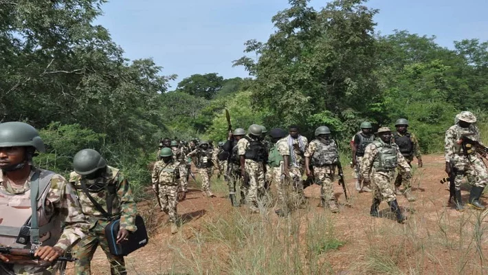
Troops of the 12 Brigade of the Nigerian Army have rescued 14 kidnapped victims in Kogi State following sustained offensive operations against...

A prosecution witness, PW17, an operative of the Economic and Financial Crimes Commission (EFCC) and Deputy Superintendent of the EFCC, DCE Ahmed...

Tension has heightened in Kogi and Niger states, following escalating insecurity in parts of the North Central, particularly after the recent killings...

The Kogi State Government has ordered the temporary closure of selected markets and motor parks in seven local government areas of the...
Operatives of the Kogi State command of the Nigeria Police Force, in collaboration with the Nigerian Army, local hunters and vigilante groups,...

The Kogi State government has explained that the decision to close down schools was a proactive step taken to safeguard pupils, students,...

The trial of former Kogi State Governor, Yahaya Bello, over alleged ₦80.2 billion fraud continued on Wednesday before Federal High Court, Maitama,...

The Kogi State Government on Tuesday ordered the immediate closure of all public and private primary and secondary schools across the state....

At least six villagers were killed in the Baidi community, Tangaza Local Government Area of Sokoto State, during a violent night raid...
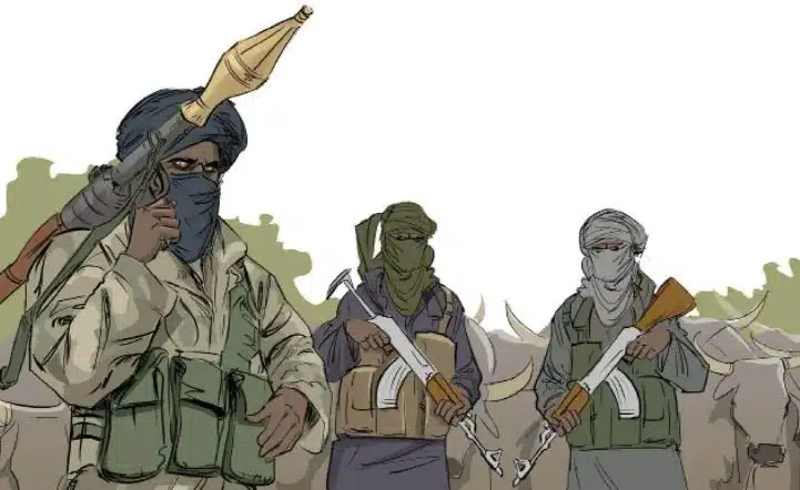
Suspected terrorists, believed to be bandits, have released 17 additional worshippers abducted from the Evangelical Church Winning All (ECWA) in Aiyetoro Kiri...
One member of the Civilian Joint Task Force (CJTF) was killed on Sunday night when suspected terrorists attacked a police position at...
Bandits have reportedly killed a man identified as Agba from Egbe community in the Yagba West Local Government Area of Kogi State,...
A review of the Kogi State draft budget for the 2026 fiscal year has shown that the state government plans to spend...
